Saturday, February 28, 2009

Holy Land Trip Day 6: The Rest of Jordan

This morning we woke up to very cold temperatures and a lot of fog. Our plan was to leave Madaba and drive north, past Amman, up to Jerash, the site of ancient Roman Gerasa. Remarkably, we found our way out of town without much trouble, despite fog so thick we could see only a few feet. It was slow going for awhile, but as the sun managed to come out and burn off the fog it turned into a pleasant drive.

The northwestern part of Jordan is the most lush and greenest section of the country. It makes quite a contrast to the desert mountains we passed through on the way down to Petra. Our only adventure on the way was getting "pulled over" by Jordanian traffic police. They do not chase after people in patrol cars, but somehow they identify the cars they wish to stop, and have a partial roadblock set up further up the highway at which they step out and wave the cars down. We were picked out and stopped, but we are not sure for what because when the officer realized we did not speak Arabic, he gave up on trying to communicate whatever it was we were doing wrong. We are lucky we did not get a ticket!

It takes a couple of hours to make it from Madaba to Jerash, but once we got there, we had no trouble finding the archaeological site. It sits directly in the middle of town, beside the highway, surrounded by everything modern in the highly polluted, dirty town of Jerash:


The site itself is fairly spectacular. Of course, we were still buzzing from Petra, and it can't compare to that, but as Roman sites go it is fairly well-preserved. The pollution and fog settling into the hills around the city even made for a picturesque, if not healthy, scene:


The monumental entrance to the ancient city, a gate built in honor of the emperor Hadrian, for whom Gerasa was a favorite city, is quite impressive.


PETER CHECKS OUT HADRIAN'S ARCH


OF COURSE THERE HAS TO BE SCAFFOLDING!

The first thing you see after passing through that arch is the hippodrome for chariot races. During the high season, there are chariot races and Roman military parades put on by costumed actors here a couple of times a day.


CAN YOU BELIEVE THIS IS THE BEST PICTURE WE HAVE OF THE HIPPODROME?


A STREET IN JERASH


PETER TAKES A SEAT

Other excellent sites include the Temple of Artemis, where we came upon a few makeshift stalls of locals selling jewelry and mint tea, which we enjoyed in the shade of the ancient columns alongside the few other tourists who had come that day.


THE TEA SELLERS SET-UP IN THE TEMPLE OF ARTEMIS

The most iconic view of Gerasa is an oval-shaped plaza, unique in the Roman world, surrounded by 160 Ionic columns:


We also went a bit further afield to see the Byzantine Church of St. George, whose remarkable mosaic floors are unfortunately sitting open to the elements, inviting more damage. These floors display excellent example of the "pixellation" of the mosaics by Muslims in later periods (see Holy Land Day 3: On to Jordan).


The most unusual thing that we saw in Gerash was not, however, an ancient monument. We had wandered into the theater, and while we were looking around, a man in a Jordanian military uniform came in with bagpipes and began playing. We were definitely not expecting that!


After a few hours at Gerash, we made the trip back to Amman, to return our rental car and catch the bus back to Israel. On the way we saw an interesting sight. An apparently highly devout Muslim man, prayer time upon him, had pulled his car over to the side of the busy mountain highway, taken out his prayer rug, and was praying on the shoulder of the road, cars whizzing past. Now that is dedication!

We got back to Amman in plenty of time to return our car, or so we thought. We had been given directions back to the rental agency by the agent who gave us our car, but for some reason he thought we would come in from Jerash on a different highway. Since that did not happen, his directions were useless to us. We had a map with us, but could not find a street that was marked with the same name as any streets on the map. We stopped in a McDonald's, where none of the workers could identify where we were on the map. They instructed us to go to a different neighborhood and that maybe someone there would know the area we were looking for. So we drove to another neighborhood, where we stopped at a Burger King. Again, everyone said we were not in the correct neighborhood, and no one could point to where we WERE on a map! But one of the guys behind the counter took pity on us and called the rental agency, who gave us directions through him. We finally made it back to the agency, but with only 20 minutes left to make it to the rendezvous with the bus! One of the men from the rental agency knew where the hotel where the bus originated was, and offered to drive us. We got to within a few dozen yards of the place, but were caught on the wrong side of a very busy divided street and had to drive another half mile until a turnaround, where the traffic light was out and the cop directing traffic (a woman, much to our surprise) was doing a terrible job and not allowing anyone to turn. It was a very nervous twenty minutes, but we finally did make it to the bus with not a moment to spare. All in all, it took us two hours from the time we arrived back in Amman to the time we found the bus. I think we were both about to pass out from the stress! (Again, Peter gets major bonus points for being able to navigate Amman, even though we didn't know where we were going!)

The bus ride back to the Israeli border was uneventful. The only site of note that we passed was Gadara, which sits right on the border of Jordan and Israel, in a very lush valley. This was the site of the miracle that Christ performed in which he caused demons (a group of them, who called themselves Legion) to move from the body of a man they were possessing into a flock of pigs, all 2000 of whom then fled off a cliff edge. (Matt 8:28; Mark 5:1; Luke 8:26).

But when we re-entered Israel, we had an unfortunate incident. The young woman border control agent (very young, perhaps 19) who was checking our passports agreed not to stamp them as we asked. But she then became distracted and "accidentally" stamped my passport. So now any plans to go to Syria in the near future are shattered, since I must either acquire a second passport or wait until the end of this trip and request a new one (my research permissions for the remainder of my time in Turkey are in the current one, so I cannot get rid of it). This was a very frustrating moment for me because we had faced so much questioning during the other four border crossings we had already made, and it was disappointing that just because the young woman was not paying attention, it had all been for nothing and now I will have to go through the lengthy and potentially expensive process of obtaining a new (or second) passport.

But I suppose, all things considered, we should be glad that we made it back from Jordan to Israel that day at all!

Saturday, February 14, 2009

Holy Land Trip Day 5: Petra!


Oh boy, this post is going to be difficult to write. Let me start by saying that Peter and I both agree that Petra is a spot that completely met all of our expectations. That is really saying a lot. It is beautiful, atmospheric, and really, really impressive. If it's not already on your list of things to see, it absolutely should be!

I'm going to use the space to post more than the usual number of pictures, since they really convey best the sense of the place. I'll put in captions where I think they are necessary.

But a LITTLE background (I just can't help myself). Petra, sometimes called the "Rose-Red City" was dug primarily out of the sheer rock of the canyons and gorges just north of the Wadi Rum desert in southern Petra. It was constructed by a civilization called the Nabateans. Historians don't know exactly where they came from, but they took over this area from the Edomites. They inhabited the site of Petra, their capital, from approximately the 3rd century BC through the 1st century AD, when the Romans moved in, made them allies, then more or less absorbed them (apparently). At the height of its glory, the city housed probably 20,000 people. The Nabateans were obviously a very advanced civilization, as you can see plainly from looking at their buildings. They also were a literate society, and archaeologists and linguists have deciphered their writing, the cursive form of which was actually the basis for the modern Arabic alphabet. We know who their gods and goddesses were, and a little bit about their way of life.

Most of the monuments you will see in these pictures were constructed by the Nabateans in the 1st century BC, although the theater is later, from the Roman period, as are a few of the temples. Also, most of what you will see are tombs and structures related to religion.

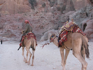
The people in the pictures are Bedouins. They have inhabited this area for centuries. In the 1980s, the Jordanian government built a nice little community for them outside the Petra park, but about 35 families have moved back into the park and live in some of the Nabatean rock-cut constructions scattered throughout the area. The others come into the park everyday. They make their living by selling handicrafts to the tourists, and giving rides on horses, donkeys and camels. It's very tempting to take them up on those -- the site is huge! Before you even really get in, it is a mile on foot from the gate to the city: a half mile through a valley and another half mile through the siq (see below). I don't know how many miles we walked (and climbed) that day, but we certainly got our exercise.

So now I'll start your "tour" of the site, and post the pictures in the order that we visited the various areas. I'll also write a few impressions here and there:


WALKING THROUGH THE SIQ, YOU CAN ADMIRE THE NABATEANS' ENGINEERING ABILITY: SEE THE WATER TROUGHS THAT RUN ALONG BOTH SIDES? IT GOES ALL THE WAY FROM A DAM IN THE VALLEY INTO THE CITY. IT WAS COMPLETELY ENCLOSED LIKE A MODERN PIPE, BUT IS NOW OPEN. THE PAVING STONES ARE ALSO ORIGINAL!


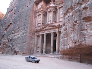
THE SIQ GETS NARROWER AND NARROWER, AND DARKER AND DARKER, THEN SUDDENLY, THERE IT IS! THE "TREASURY", THE MOST FAMOUS MONUMENT IN PETRA.


OK, SO NOT ALL BEDOUINS RIDE CAMELS AND DONKEYS. BUT THE TRUCK DOES GIVE YOU AN IDEA OF THE SCALE!

We were almost the first people there -- two young men made it in ahead of us, but we never saw them again. Until noon when we came down to the main area for lunch, we had the place mostly to ourselves, besides the Bedouins. That is really rare!


SOME BEDOUINS IN FRONT OF ONE OF THE TOMBS THAT IS NOW UNDER SCAFFOLDING (OF COURSE).


PETRA TAXI SERVICE


THIS HAS TO BE THE WORST JOB IN THE PLACE

The first thing we did was climb to the "High Place of Sacrifice." As advertised, it was high. Along the way, we acquired a kitty "guide" who climbed with us most of the way in return for some cheese and water.


Here are some views of, and from, the High Place of Sacrifice:


THE TOMB OF AARON ON THE HIGHEST MOUNTAIN IN PETRA: THREE HOURS BY HORSE PLUS A THREE HOUR CLIMB AWAY.

On our way back down by a different route, we saw quite a few monuments, and met some Bedouins:


PETER INSPECTS THE TRICLINIUM TOMB


THE INTERIOR OF THE TRICLINIUM IS CARVED, TO TAKE ADVANTAGE OF THE BEAUTIFUL NATURAL PATTERNS IN THE ROCKS


THE NABATEANS ALSO CARVED IMAGES INTO THE CLIFF FACES. THIS IS THEIR GODESS, AL-UZZA, WHO HAD THE FORM OF A LION.

Sometimes, as we climbed the rocks, we heard sounds that we could not identify, and we could not see any source for them. They might have been birds, animals, or maybe even the Bedouins. They must have some language they can use to communicate over a great distance in these canyons. There is also a certain type of bird that lives there that mimics the sound of a laughing child, so we often did not know what we were listening to. The donkeys and camels also often made loud noises that echoed around off the rocks.

We saw many Bedouin women and their children. Many of the women have tattooed faces.


THIS BEDOUIN GIRL WAS SORTING ROCKS TO SELL TO TOURISTS


HER FAMILY ALSO HAD A BABY GOAT THAT THEY WERE MILKING WITH A BOTTLE


THIS IS A VIEW FROM THE OLD MUSEUM, WHICH IS IN ONE OF THE CAVE-STRUCTURES. I LIKE IT BECAUSE IT PROVES HOW FEW PEOPLE WERE THERE THAT DAY. FEBRUARY IS THE PERFECT TIME TO VISIT!

After a break for an awesome buffet meal, we were ready for another adventurous climb, this one up more than 800 stairs (some original, carved Nabatean stairs, some put in for the benefit of modern tourists). Our goal this time was the largest monument in Petra, know as the Monastery. It is on another peak opposite the High Place of Sacrifice. There were more tourists making this trek than to the High Place, but we still had some of the trail to ourselves. We could have taken donkeys, but we didn't.


It is difficult to describe what it is like to come to the top of the mountain, turn a corner, and see this massive construction. It may have been a temple, and it was almost definitely used as a church after the Nabateans converted to Christianity in the 4th century -- there are many crosses carved on the inside, although we did not go in.


CAN YOU FIND ME?


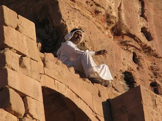
THERE I AM! I WAS IMPRESSED WITH MYSELF FOR CLIMBING THAT BIG ROCK UNTIL I SAW THIS YOUNG BEDOUIN GUY:


LOOK AT THE PICTURES OF THE MONASTERY AGAIN. HE IS HANGING FROM THE VERY TOP! SHOWOFF!

From There, there was only one place we could go:


A JORDANIAN SCARECROW?

From the viewpoint at the "End of the World" we could see the Arabian Desert stretching out just beyond the mountains. That adventure will have to wait for another trip.


YOU CAN SEE THE ARABIAN DESERT BEYOND THE MOUNTAINS.

By the end of the day we again had the place almost to ourselves, again except for the Bedouins:


WAIT A MINUTE...THIS ISN'T QUITE RIGHT!


DOING HOMEWORK ON THE WAY HOME ON THE "SCHOOLBUS"

We took the advice of a young Bedouin and climbed to the platform of one of the Royal Tombs to watch the sun set. We were not the only ones with the idea:


WATCHING THE SUNSET FROM THE ROYAL TOMBS


HAVING A SMOKE AT DAY'S END


Below us, a Bedouin boy sauntered by on his donkey, playing on some kind of flute. Besides that and the sounds of the camels who were restive at the end of the day, it was completely peaceful. After the sun went below the horizon, we made our way back to the entrance. By the time we were halfway back through the siq it was almost completely dark and very, very still. Thankfully, it was light enough outside the canyon to easily find our way back along the road to the visitor's center. Along the way we turned down one last offer for a horseback ride to the gate -- VERY tempting at that point! When we got back to the entrance, we had to stop for one more picture:


ME AND MY HERO!

We left Wadi Musa right away and drove back to Madaba for the night. We took the Desert Highway this time, because we knew it was straight, and thought it would be faster. We had no idea that it had speed bumps every few miles. Imagine, a highway with speed bumps! Also, the guy at our hostel had told us there would be somewhere to stop and eat on the way. Sure, if you count butcher shops with big raw hunks of eat hanging in the windows. Apparently there is no concept of fast food in Jordan, or of having any kind of services along the main highway. We did not want to wander off into a little town in the dark with no idea of where we were going, so we stuck it out and got back to Madaba almost 3 hours later, very hungry and kind of cranky. The owner of our hotel was kind enough to order food sent over for us. I guess that's the kind of service you get when you are the only guests in the place.

Friday, February 13, 2009

Holy Land Trip Day 4: Tour of Jordan, North to South!

This was the day we drove from Madaba to Wadi Musa (the little town outside of Petra), stopping along the way. As with our day in Galilee, we had picked out quite a few sites we wanted to visit en route, and we fully expected that we might not be able to make them all. But we did!

We left Madaba fairly early, and our first stop was a detour west off the King's Highway, which we intended to take all the way to Wadi Musa. But first we wanted to go to the top of Mt. Nebo. This was the spot from which the Bible says God showed Moses the Promised Land of Canaan before he died: "Then Moses climbed Mount Nebo from the plains of Moab to the top of Pisgah, across from Jericho. There the LORD showed him the whole land—from Gilead to Dan, all of Naphtali, the territory of Ephraim and Manasseh, all the land of Judah as far as the western sea, the Negev and the whole region from the Valley of Jericho, the City of Palms, as far as Zoar. Then the LORD said to him, "This is the land I promised on oath to Abraham, Isaac and Jacob when I said, 'I will give it to your descendants.' I have let you see it with your eyes, but you will not cross over into it." (Deuteronomy 34).

These are exactly the areas that you can see today from the mountaintop. Although it was raining slightly when we arrived, we could still see remarkably far, and as it cleared up a bit, the clouds made fantastic patterns of shadows on the hills and valley. It was really striking:


Archaeologists have been working there for quite some time, uncovering evidence of Byzantine churches dedicated to the memory of Moses. The excavation was closed when we were there, but we were mostly there for the view, so it didn't really matter too much. There was an interesting, but small, exhibition of things related to the history of the excavations. I found these two pictures quite amusing:


THE FIRST ARCHAEOLOGICAL TEAM THAT WORKED HERE


THIS ONE WAS LABELED "FIRST DAY IN THE FIELD." THEY SURE HAVE THEIR WORK CUT OUT FOR THEM!

From Nebo, we doubled back to join the King's Highway and got lost (again) briefly in Madaba. I did see a funny sign there while we were wandering around, and although I did not get a picture of it, I thought some of you might find it amusing. It was an advertisement for a Turkish bath in town proudly touting its "Tot Tiled Floor!"

We drove on to another site with Biblical associations, the hilltop fortress of Herod known as Machaerus. Tradition says that this was the spot where the daughter of Herodias danced for Herod the Great and, captivated with her, he promised her anything she wanted. At the urging of her mother, the girl asked for the head of John the Baptist on a plate, and it was here that legend says Herod had him executed and the head presented to his wife and her daughter. (The Biblical passages are Matthew 14: 1-12 and Mark 6: 14-29, although no specific location is given for the events).

It is an astonishing site. Incredibly, it is not even mentioned in the "Eyewitness Travel" guidebook we had, but we had seen it in a book on Jordan in the library here, and were able to find it on another map of the country besides the one in the guide, but we were basically on our own to find it. I get the idea that it is COMPLETELY off the normal tourist itinerary (it's a shame), since we had to drive a fair distance off the highway to reach it. Then we became confused in a village because we did not realize that the site would be marked as a "Shrine of the Prophet Yahya" (now we know that's John the Baptist to Muslims). When we found the parking lot, we realized that the fortress itself was high on a lonely mountaintop, and it would require some serious uphill hiking to reach it!


VIEW OF MACHAERUS FROM THE PARKING LOT -- CAN YOU SEE IT ON TOP OF THE FLAT MOUNTAINTOP THERE?

But it was early in our trip and we were still full of energy, so we did it. And we are SO glad we did! The view was spectacular, particularly of the Dead Sea. The ruins are interesting, but there is not that much to see of them. It is really the feeling of isolation that gives the place its appeal, and of course it gives a unique understanding of the power (and the paranoia) of Herod.


A ZOOM VIEW OF THE RUINS OF THE FORTRESS. THE SQUARE BUILDING IS A MODERN SHELTER FOR THE CARETAKER, WHO WAS NOT THERE.


VIEW FROM THE FORTRESS. THAT'S THE DEAD SEA. YES, MY EYES ARE CLOSED -- IT WAS REALLY BRIGHT UP THERE!

It was quite cold at the top, so we did not stay long. Also, just when we made it to the top we looked down and saw someone standing near our rental car (wouldn't you know it?), so we decided to head back down after only a few minutes. Our car was fine -- it was probably just a curious local, surprised to see someone stopping there in the off-season. There were several caves on the surrounding hills and mountains that seem to be the homes of small families, and we saw one man herding his goats in the ravine below. It was all very peaceful and beautiful.


On the way back down, we did make one stop: we went inside the cave that tradition says was the lonely cell where Herod kept John the Baptist up until his execution:


Our next stop on the way south was the Crusader castle at Kerak. But before we could reach it we had a couple of hours of driving to do along the King's Highway. We had no idea what to expect, but the scenery turned out to be amazing. When we weren't driving through desert mountains, we were passing through tiny towns. People were definitely surprised to see us. The further south we went, the more they seemed to be interested in us, and eventually I started covering my head when we drove through the towns, which cut down on the staring quite a bit. Again, I think most tourists just don't drive through there in a car. And the buses probably take the Desert Highway, which is to the east and runs straight through the flat desert. But it is not nearly as scenic as the route we took! One interesting thing that you can see all over Jordan, in the big cities, the small towns, and scattered along the roadways, are "unfinished" houses, like these:


One of our friends here at the Research Institute informs us that "unfinished" structures are not taxed in Jordan, so people are more than willing to leave unsightly metal bars sticking up out of their roofs to prove that they are eventually going to add another story, thus rendering their building "unfinished" and non-taxable!

The further south we went, the more completely we were surrounded by the desert. But there are also wadis (ravines which are filled with water in the brief rainy season), so there are spots with trees and vegetation. We also got to drive over the massive Al-Mujib dam, built over the wadi of the same name. We had no idea it was there, and then suddenly we came around the corner and there was a huge, HUGE dam.


A CLOSEUP. WE THOUGHT FOY MIGHT LIKE TO SEE IT.

All in all, the drive through the empty landscape was very interesting and impressive, but we would not want to do it at night -- lots of sheer drop-offs, hairpin curves, and not so many people around in case of trouble. We did, however, see some Bedouins camping in one of the valleys near the wadi.


A JORDANIAN ROAD CONSTRUCTION CREW. NOT A JOB I WOULD WANT.


A BEDOUIN ENCAMPMENT. THE TENTS ARE PROBABLY CAMEL-HAIR.

After descending to the bottom of the wadi canyon where the dam is, we climbed back up the other side. At the top rim we spotted a few places where the adventurous traveler could stay if they wanted to enjoy the scenery and the emptiness: The "Sunshine Resthouse" the "Rest House Trajan" and the "Black Iris Camping" area. Just throwing that out there. Interestingly, when we got back to the top of the canyon, the landscape on the other side went from being dusty yellow colored to an amazing, deep red. This is basically the same color that the rock of Petra has in it, and I'm sure some geologist could explain what type of landscape we had moved into, but all I know is that it was really pretty!

A few other things of note that we encountered as we drove were some Roman ruins in the town of Ar-Rabba (we did not stop), and several checkpoints of military and police groups at crossroads (we did not have to stop very often -- they didn't seem TOO interested in us, as long as we slowed down and waved at them, but occasionally they wanted to know where we were from and where we were going). Also, interestingly, the road signs were less and less frequently translated into English the further south we got. Anyone traveling here should be prepared for that -- having someone who can read Arabic would be a big help! Also, those signs that WERE translated into English were inconsistent -- the name of a town or a site would change in spelling, sometimes drastically, from sign to sign. You really have to work entirely on phonetics, saying each sign out loud and then figuring out what it is for. For instance, the Crusader castle of Shobak (see below) showed up these several ways, all within a few miles:
Shobak
Ash Shobak
Ash Shawbak
Al-Shawbak
And these were all "official" road signs posted by the government.

Other dangers of driving in rural Jordan include sheep, goats, dogs and donkeys, the latter of which are often hobbled by their owners with straps on their ankles so they can't get far, then sent out to wander freely. This means they CANNOT get off off the road quickly!


TRAFFIC JAM ON THE KING'S HIGHWAY

But obviously we survived the drive without incident and made it to Kerak. This city was once the capital of Moab, and this was an important fortress for the Crusaders since it was highly defensible -- it is surrounded by sheer cliffs on three sides. It is a very popular site because it has been heavily "restored" (freely interpreted and rebuilt might be a better description), so it is easy to understand. Also, it is simple to get to -- it is in the center of the sizeable town of Kerak, which also means we had somewhere to eat and stock up on road provisions. We acquired a guide in the site that we did not really want, but he was very friendly.


THE CRUSADER CASTLE OF KERAK


PETER EXPLORES THE CASTLE


PETER AND OUR FRIENDLY GUIDE

And, for the first time that day we encountered other tourists: two men from, of all places, Concord, California. They were Rotary Club members on their way to Ethiopia to assess a clean water project they are starting there. I have to say, it was nice to talk to some other Americans for a few minutes (especially since they weren't a huge, annoying tour group of Americans).

From Kerak we drove further south to another Crusader fortress, this one called Shobak. This castle, built in 1115, was one of the first Crusader outposts constructed to the east of the Jordan river, and it controlled the important road between Egypt and Damascus. It was conquered in 1189, and there are Mameluke inscriptions and some of their stonework here (the Mamelukes were an Egyptian Muslim dynasty). It is quite an impressive site, well worth a visit. Unlike Karak, it is isolated and has had little reconstruction done. We liked it more! There were no other tourists there, only a few locals who live in cave-houses nearby and apparently like to hang out in the ruins (who wouldn't?). We arrived just before the sun started to go down and paint the surrounding desert amazing colors, casting shadows of the castle on the mountains:


SHOBAK FROM A DISTANCE


YOU CAN SEE THE CASTLE'S OUTLINE IN THE SHADOWS ON THE HILLSIDE


SHOBAK CASTLE: A LOCAL HANGOUT

At that point, our light was failing and we had to move on to Wadi Musa, where our hostel was located. We managed to get there just as the sun fell behind the massive mountains that hide Petra. It was so exciting to stop and take pictures, and try to figure out which gorge might be the siq, the entrance to the ancient city!


PETRA IS OUT THERE SOMEWHERE!

When we arrived at our hostel, we were given tea and sat down to chat with the man working the counter. Two other guests came out to the lobby, a couple of young ladies from Australia. We got to talking with them and discovered that they also live in Istanbul! They teach English to elementary school children here. What a small, small world it really is.

We were also pleased to find that our room had a fine view of the mountains, so we were able to say goodnight to them, and then wake up eagerly the next morning bright and early to head to the park! It was like the night before Christmas -- we were both so excited to finally see something we had dreamed of seeing for years.


THE TOWN OF WADI MUSA AT NIGHTFALL